Un itinerario panoramico, che percorre gli insediamenti militari della prima guerra mondiale nella zona di Ornavasso.
..
Da Verbania mi dirigo verso Fondotoce e raggiungo l’ingresso alla Riserva Naturale, nei pressi di un ponte in legno.
From Verbania I go towards Fondotoce and I reach the entrance to the Natural Reserve, near a wooden bridge.
Da qui percorro la strada sterrata in direzione della spiaggia, che raggiungo rapidamente.
From here I drive the dirt road towards the beach, that I reach quickly.
Lascio la spiaggia e percorro il divertente singletrack che costeggia il fiume Toce. La traccia ben presto si allarga, continuando a costeggiare il fiume e passando sotto la strada per Feriolo e poi sotto la ferrovia, fino a giungere sotto la strada statale per Gravellona Toce. Qui proseguo su traccia stretta fino a giungere sulla strada asfaltata a Prà Michelaccio. Mi dirigo verso l’inceneritore, piccola deviazione a destra su stretto sentiero che però sbuca subito sulla pista ciclabile.
I leave the beach and drive the fun singletrack along the Toce River. The trail soon widens, continuing along the river, passing under the road to Feriolo and then under the railway, then arriving under the main road for Gravellona Toce. Here I continue on trail until I reach the asphalt road in Prà Michelaccio. I headed to the incinerator, a small deviation to the right of the narrow trail but immediately comes out on the bike path.
Seguo la pista ma dopo circa un chilometro la lascio per prendere una strada sterrata sulla destra. Percorro lo sterrato, devio a sinistra e proseguo sul sentiero principale fino a sbucare su una stradina. Sinistra, destra e continuo su largo sterrato fino a riprendere la pista ciclabile, accanto alla ferrovia. La percorro fino alla fine e raggiungo la passerella di Ornavasso.
I follow the path but after about a kilometer I leave it to take a dirt road on the right. I drive the dirt road, toggle to the left and go to the main trail until I reach a small street. Left, right and continue along a wide dirt road to resume the bike path next to the railway. I drive to the end and hit the footbridge of Ornavasso.
Attraverso il ponte e raggiungo Ornavasso. Attraverso la strada statale e prendo la strada in salita in direzione del Boden. Una salita non molto dura e panoramica.
I across the bridge and reach Ornavasso. I through the main road and take the road uphill in the direction of Boden. A climb not very hard and overview.
Dopo alcune curve raggiungo il tornante nei pressi dell’antica cava.
After a few turns I reach the bend near the ancient quarry.
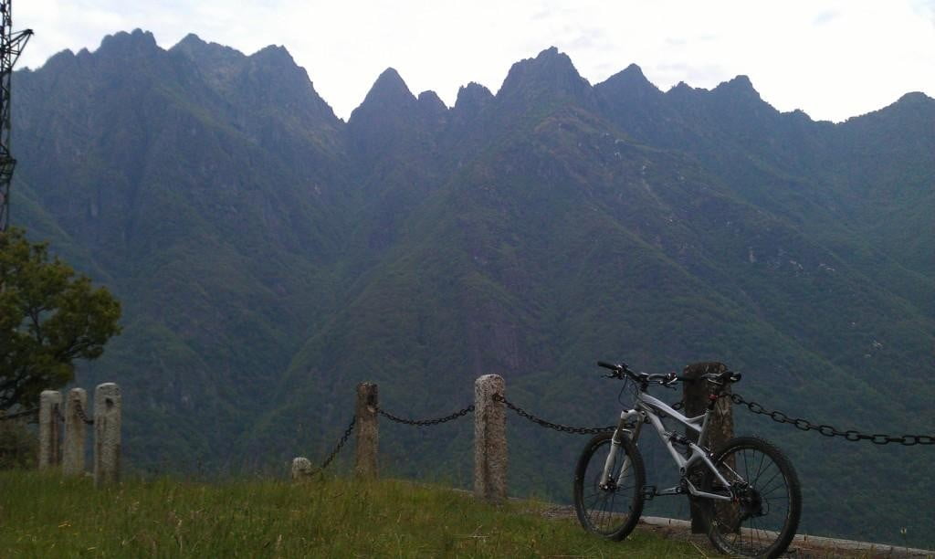
Imbocco la strada sterrata sulla destra che, pianeggiante, mi conduce a Forte di Bara. Splendido panorama.
I take the dirt road on the right, flat, leading me to Fort Bara. Beautiful scenery.
Ora mi aspetta la discesa lungo la tortuosa strada sterrata.
Now go down along the winding dirt road.
Lungo il percorso si possono osservare i resti di alcune gallerie e trincee della Linea Cadorna.
Along the way I can see the remains of tunnels and trenches of the Cadorna Line.
Alla fine della discesa giungo al cannone di Migiandone.
At the end of the descent I arrive at the cannon of Migiandone.
Raggiungo Migiandone e imbocco la strada sterrata sulla destra che passa sotto l’autostrada. Seguo i piloni dell’autostrada fino alla fine e poi a destra, ancora su sterrato, proseguo fino a raggiungere una pista ciclabile. Sinistra, passo sotto la ferrovia e mi ritrovo sulla strada statale. Ritorno alla passerella di Ornavasso, vi passo sotto e percorro lo sterrato che costeggia l’altro lato del fiume.
I reach Migiandone and take the dirt road on the right that goes under the highway. I follow the pylons of the highway to the end and then right again on dirt, I continue until I reach a bike path. Left, step under the railway and I find the main road. Back to footbridge of Ornavasso, I pass under it and I drive the dirt road that runs along the other side of the river.
Ad ogni bivio continuo sempre a costeggiare il fiume. Supero alcune pozze di acqua piovana e alla fine mi ritrovo su un divertente ma breve singletrack, al termine del quale a sinistra, destra e su largo sterrato raggiungo la strada asfaltata. Attraverso la strada, passo sotto l’autostrada, poi sotto la ferrovia e mi ritrovo su un lungo sterrato, nei pressi di un punto di atterraggio per i parapendii.
At each fork in the road I always continuous along the river. Overcome some puddles of rainwater and I end up on a fun but short singletrack, after which on the left, right and I reach a wide dirt road. Across the road, passed under the highway, then under the railway and I find a long dirt road, near a landing spot for paragliders.
Proseguo sempre dritto fino alla fine, ripasso sotto la ferrovia e ritrovo la strada asfaltata a Campone. Destra e alla rotonda subito a sinistra passando davanti al campo sportivo. Quindi a sinistra imbocco uno sterrato che voltando a sinistra e poi a destra passa sotto l’autostrada. Costeggio l’autostrada verso Gravellona Toce e raggiungo l’imbocco di una pista ciclabile. La percorro prima su asfalto e poi su sterrato, fino a raggiungere il ponte sul torrente Strona.
I continue straight ahead until the end, pass under the railway and find the asphalt road in Campone. Right and at the roundabout immediately left passing the sports field. Then I take on the left a dirt road, pass under the highway and drive along the highway towards Gravellona Toce. I reach the entrance to a bike path. I drive it before on asphalt and then on dirt road, until I reach the bridge over the Strona Creek.
Attraverso il ponte e percorro lo sterrato in direzione Fondotoce ritrovandomi a costeggiare ancora una volta il Toce.
I drive across the bridge and the dirt road in the direction of Fondotoce, again along the Toce.
Il Mont’Orfano si specchia nel fiume.
The Mount Orfano is reflected in the river.
Giungo, quindi, sotto la ferrovia.
I arrive, therefore, under the railway.
Qui lascio il fiume e costeggio la ferrovia, quindi, seguendo sempre il sentiero principale, raggiungo la strada asfaltata. Sinistra e dopo un breve tratto sono sulla strada per Feriolo. Attraversata la strada, percorro il ponte sul Toce, quindi scendo verso il sentiero sottostante, in direzione Fondotoce e ritorno al ponte in legno di inizio percorso. Da qui ritorno a Verbania.
Here I leave the river and drive along the railway, therefore, always following the main trail, I reach the asphalt road. Left and after a short distance I am on the road to Feriolo. Across the street, I drive the bridge over the Toce, then go down to the trail below, in the direction of Fondotoce and return to the wooden bridge at the beginning path. From here I return to Verbania.
(km 49, dislivello totale in salita circa 290 m)
(km 49, total climb uphill about 290 m)


