Il Monte Rosso, la montagna che sovrasta Verbania, in questo itinerario viene raggiunto per poi tuffarsi nella valle del Torrente San Bernardino.
..
Da Intra mi dirigo verso Suna, percorro la strada statale e quindi prendo la strada per Cavandone. Appena svoltato devio a sinistra imboccando la stradina in salita, a tratti panoramica.
From Intra I headed to Suna, drive the road and then take the road to Cavandone. Once I have turned I switch to the left uphill path, sometimes overview.

Raggiungo un tornante che riporta sulla strada principale. Io, invece, proseguo sul sentiero a sinistra, in leggera salita fino ad arrivare ad un ponticello in legno.
I reach a bend which back onto the main road. However, I continue on the trail to the left, slightly uphill until I reach a wooden bridge.

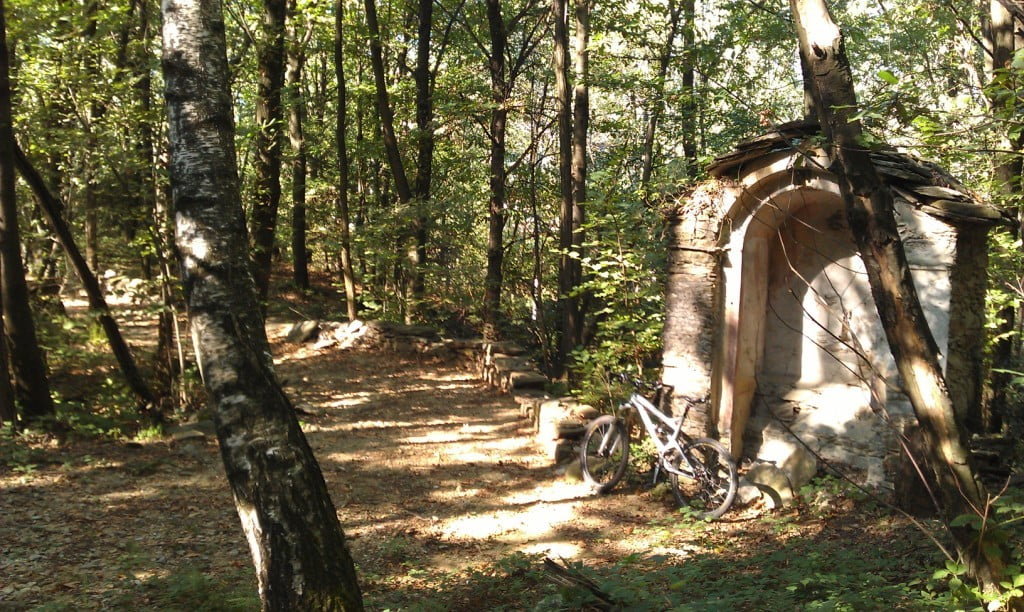
Un breve tratto e raggiungo La Torraccia, un’antica torre nel sistema di avvistamento degli antichi feudatari Borromeo.
A short stretch and I reach The Torraccia, historic tower in the sighting system of the ancient feudal lords Borromeo.


Da qui proseguo a piedi sulla mulattiera, un paio di centinaia di metri e raggiungo la chiesa della Madonna del Buon Rimedio, che offre un bellissimo panorama sul lago.
From here I continue walking on the mule track, a couple of hundred meters and hit the church of Madonna Buon Rimedio, which offers a beautiful view of the lake.


Riprendo la strada asfaltata ed al terzo tornante la lascio per imboccare il sentiero sulla sinistra, che in salita mi porta ad un’altra chiesa con il caratteristico Tasso pluricentenario.
I take the asphalt road and at the third curve I leave this road and take the trail on the left, uphill brings me to another church with the characteristic centuries old Taxus.


Ritorno ancora su strada asfaltata e dopo alcuni tornanti giungo alla piazzetta di Cavandone.
Back again on the asphalt road and after a few bends come to the square of Cavandone.

Proseguo su questa strada, un paio di tornanti ancora e l’asfalto termina e diventa strada sterrata. Si continua a salire, una breve serie di tornanti e raggiungo uno spiazzo con un abitato. Proseguo a sinistra, sempre su larga traccia, ancora un paio di tornanti in salita e mi immergo nel bosco del Monte Rosso.
Percorro un veloce sterrato e dopo una breve discesa raggiungo una sbarra. Superata la sbarra sono in un’area pic-nic che offre un notevole panorama sul lago.
I continue on this road, a couple of bends and even the asphalt ends and becomes a dirt road. It continues to rise, a short series of bends and I reach a clearing with a building. I continue to the left, always on a large track, still a couple of turns uphill and immerse myself in the woods of Mount Rosso.
I drive on a fast dirt road and after a short descent reach a bar. After passing the bar I am in a picnic area that offers a wonderful view over the lake.


Riprendo l’asfalto e comincio a scendere. Al 4° tornante prendo la strada sterrata a destra. Inizialmente si sale, poi si scende e infine si prosegue in piano, fino a giungere al punto in cui la traccia si restringe e potrebbe costringere a proseguire a piedi per un breve tratto con gradoni in pietra. Proseguendo in discesa si raggiunge una piccola costruzione. Qui devio a destra su traccia non molto evidente, fino a raggiungere un largo sterrato. Breve salita, poi discesa e ritorno a quell’abitato visto in precedenza. Rifaccio, quindi, il percorso a ritroso e ritorno a Cavandone. Superata la piazzetta, dopo il primo tornante imbocco il sentiero sulla destra, proseguo tenendo la destra e raggiungo un bivio con una cappelletta.
I take the asphalt and begin to descend. At the 4th bend take the dirt road on the right. First go up, then down, and finally, continue straight until I reach the point where the track narrows and may force to walk for a short distance with stone steps. Continuing downhill I reach a small building. Here switch right on track not very obvious, until I reach a wide dirt road. Short ascent, descent and then return to that building seen previously. Redo, therefore, the backward dirt road and return to Cavandone. Past the square, after the first bend I take the trail path on the right, I continue keeping to the right and reach a junction with a small chapel.
Quindi ancora un’altra cappelletta.
So yet another chapel.

Proseguo a destra e comincio a scendere con decisione, fino a raggiungere una stradina asfaltata a Bieno. Continuo a scendere e arrivo sulla strada principale. Destra e al semaforo inizio a salire verso il paese. Quasi al culmine della salita devio a destra attraversando alcune abitazioni e mi ritrovo su una strada sterrata che scende fino a riprendere la strada asfaltata nei pressi di una catena. Prendo la strada in discesa, in direzione di Trobaso, e giunto al bivio devio a sinistra in salita e raggiungo rapidamente Santino.
I continue to the right and began to firmly descend, until I reach an asphalt road in Bieno. I continue down and arrive on the main road. Right and at the lights I start to climb towards the village. Almost at the top of the slope I turn to the right, through some houses and I find myself on a dirt road that goes down to take the asphalt road near a chain. I take the downhill road, in the direction of Trobaso, and come to the fork I turn left uphill and reach quickly Santino.

Proseguo sulla strada principale e raggiungo anche Rovegro, con il suo monumento ai caduti.
I continue on the main road and also reach Rovegro, with its war memorial.

Proseguo ancora lungo la strada principale e arrivato al grande parcheggio prendo il sentiero in salita, fino a ritrovarmi su una canalina in cemento.
Yet I continue along the main road and arrived at the large parking I take the trail uphill, until I was on a cement canal.

Continuo in questa direzione e mi ritrovo ad attraversare un ponte in ferro.
I continue in this direction and I find myself to cross an iron bridge.

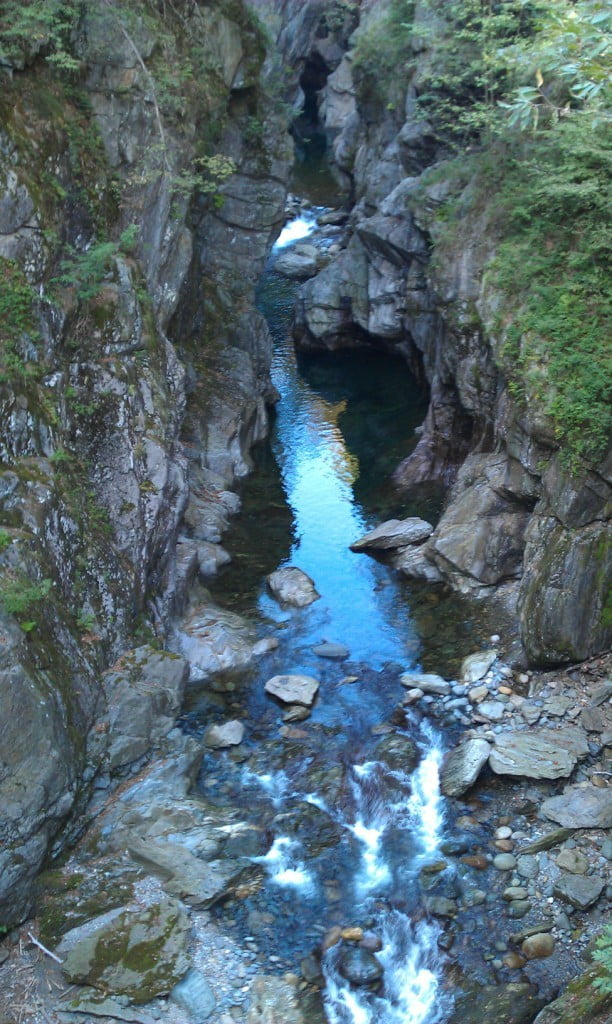
Raggiungo rapidamente la strada asfaltata che conduce a Cicogna. Attraverso la strada e mi immetto sul sentiero a destra proprio sotto la strada. Il sentiero è anch’esso una canalina dell’acqua e mi fa giungere ad una chiusa. Qui dietro-front ed a ritroso faccio ritorno a Rovegro e raggiungo il cimitero. Da qui prendo il sentiero a destra che costeggia il cimitero e in discesa su gradini in pietra raggiungo il caratteristico Ponte Romano.
I quickly reach the asphalt road that leads to Cicogna. Across the road and I enter the trail to the right just below the street. The trail is also a water canal and makes me come to a close. Here I go back and return to Rovegro and go towards the cemetery. From here I take the right trail that runs along the cemetery and down the stone steps I reach the typical Roman Bridge.


Proseguo in salita, a spinta sui gradoni in pietra, ma ad un certo punto lascio questo sentiero per prendere quello evidente davanti a me pianeggiante e pedalabile. Raggiungo un campo sportivo e riprendo la strada asfaltata. Percorro la strada in salita e raggiungo Cossogno.
Da qui proseguo in direzione di Verbania e quindi svolto a sinistra verso Ungiasca.
La salita è dura e dopo una serie di tornanti sono finalmente ad Ungiasca. Prendo la strada pianeggiante verso Miazzina, ma la lascio subito per prendere il sentiero poco evidente sulla destra, nei pressi di una costruzione in lavorazione.
Si tratta di un sentiero divertente che scende deciso in direzione dell’Oratorio di Monscenù.
I continue to climb, push on the stone steps, but at some point I leave this trail to take another trail in front of me flat and pedaled. I reach a sports field and I take the asphalt road. I drive the road uphill and reach Cossogno.
From here I continue in the direction of Verbania and then I turn left towards Ungiasca.
The climb is hard and after a series of bends I arrive finally at Ungiasca. I take the flat road towards Miazzina, but I immediately leave it and take the right trail near a construction work.
It is a fun trail that firmly descends in the direction of the Oratory of Monscenù.

Verso la fine della discesa, prima di arrivare all’Oratorio, devio a destra nei pressi di una sbarra ed attraverso la pineta in discesa.
At the end of the descent, before arriving at the Oratory, toggle right next to a bar and through the pine forest downhill.

Scendo con decisione, su traccia inizialmente poco evidente e poi più marcata. A fine discesa raggiungo un guado, di questi tempi asciutto, lo supero e devio a sinistra fino a ritrovarmi nei pressi del canile di Cossogno. Tengo la sinistra e mi ritrovo nel Pian di Les. Proseguo sempre dritto sul sentiero principale, fino a raggiungere una cappelletta. Ancora dritto e poi piego a sinistra cominciando a scendere con decisione su una pietraia. Al bivio tengo la destra e raggiungo Unchio. Riprendo la strada asfaltata e scendo verso Trobaso. All’incrocio volto a destra e vado a prendere la ciclabile di Trobaso. Mi porto alla fine della ciclabile per immettermi sul sentiero che costeggia il Torrente, in alcuni punti panoramico.
I go down firmly on track initially not very evident and then more pronounced. At the end of descent reach a woad, these days dry, I overcome it and I am near the Cossogno’s doghouse. I keep the left and I am in Pian di Les. I continue straight on the main trail until I reach a small chapel. Still straight and then bend to the left starting to come down firmly on stony ground. At the fork, keep right and I reach Unchio. I take the asphalt road and go down to Trobaso. At the intersection I turn right and I go to take the bike path of Trobaso. At the end of the bike path I take the trail that runs along the creek in some scenic spots.


Proseguo fino a risalire sulla ciclabile. Breve tratto stradale e riprendo un’altra ciclabile costeggiando, però, il torrente su sterrato. Infine di nuovo ciclabile e raggiungo Renco e, quindi, Verbania.
I continue to go back on the bike path. Short stretch of road and resume another bike path, however, on a dirt road along the creek. Finally a new bike path and I reach Renco and, therefore, Verbania.
(km 42, dislivello totale in salita circa 880 m)
(km 42, total climb uphill about 880 m)


