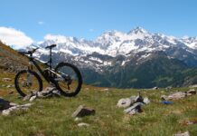
Una lunga e dura salita per raggiungere uno spettacolare punto panoramico sul Lago Maggiore.
..
..
Da Verbania prima via ciclabile e poi sterrato costeggio il Torrente San Bernardino e raggiungo Trobaso, da dove salgo a Cambiasca. Qui mi aspetta una scorrevole strada sterrata che mi porta a Ramello. Salgo sulla strada provinciale e percorro la Valle Intrasca, con i suoi splendidi scorci sul Torrente San Giovanni.
From Verbania I reach Trobaso, first by bike path and then by dirt road along the St. Bernardino Creek, from where I climb to Cambiasca. Here I drive a smooth dirt road that leads me to Ramello. I climb toward the provincial road and drive the Intrasca Valley, with its splendid views over the St. Giovanni Creek.
Supero Ponte Nivio e Ponte Laura e comincio a salire verso Aurano. Dopo una serie di tornanti in salita raggiungo Aurano con il suo belvedere sulla valle.
I overcome Nivio Bridge and Laura Bridge and then start to climb towards Aurano. After a series of hairpin bends uphill I reach Aurano with its lookout over the valley.
Da qui la salita si fa più dura, ancora qualche tornante ed arrivo all’Alpe Segletta.
From here the climb is harder, yet few hairpin bends and I arrive at Alpe Segletta.
La salita non è ancora terminata ma comincia a diventare panoramica.
The climb is not over yet but it starts to get overview.
Ultimo tratto in leggera salita e raggiungo Piancavallo con il suo splendido panorama.
Last gentle upward stretch and I reach Piancavallo with its splendid landscape.
Dopo una breve sosta prendo la strada in discesa in direzione di Pian di Sole. Supero Alpe Manegra e da Luera comincio a salire leggermente fino ad arrivare a Pian di Sole. Da qui verso Premeno lungo vecchie strade.
After a short break I take the descent road towards Pian di Sole. I overcome Alpe Manegra and from Luera I begin to rise slightly until I reach Pian di Sole. From here to Premeno by old roads.
Raggiungo, quindi, Pian Nava. Da Pian Nava un ripido sterrato mi porta fino ad Albagnano.
Then I reach Pian Nava. From Pian Nava a steep dirt road takes me up to Albagnano.
Da Albagnano su asfalto fino a Bée, dove prendo la strada sterrata sotto la strada provinciale e raggiungo Bureglio. Ancora asfalto per un breve tratto per immettermi nel bosco di S. Martino. Lo attraverso e raggiungo Vignone. Quindi per asfalto fino a Zoverallo e, infine, Verbania.
From Albagnano by asphalt to Bée, where I take the dirt road under the provincial road and I reach Bureglio. Still asphalt for a short distance to putting in the woods of St. Martino. I drive through it and I reach Vignone. So by asphalt to Zoverallo and, finally, Verbania.
(km 39, dislivello totale in salita circa 1100 m)
(km 39, total climb uphill about 1100 m)


